
Earthquake in Pontefract: Seismic activity registering on the Richter scale felt in Pontefract over the weekend
Movement registering on the Richter scale was felt in Pontefract over the weekend.
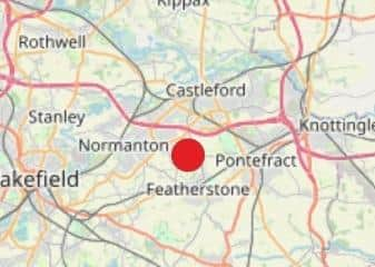
The British Geological Survey (BGS) website recorded that the ‘earthquake’ took place yesterday (Sunday, September 7) at 8.49am, near Pontefract.

On average, several hundred earthquakes are detected by the British Geological Survey throughout the country each year, but almost all of them are far too faint to be felt by humans.
The ‘earthquake’ registered at 2.6 on the Richter magnitude scale – which measures the strength of earthquakes across the world.
This is the highest recorded earthquake on that scale within the country, since a 3.1 one in Inchlaggan, in Scotland, on August 1.
The specific latitude of the Pontefract quake was 53.693329, whilst the longitude was -1.366.
The BGS also recorded that the depth of the movement was 27 kilometres.
Posting to social media, on Pontefract resident said: “Anyone feel the earth move this morning?” Whilst another said they felt “very slight movement”.